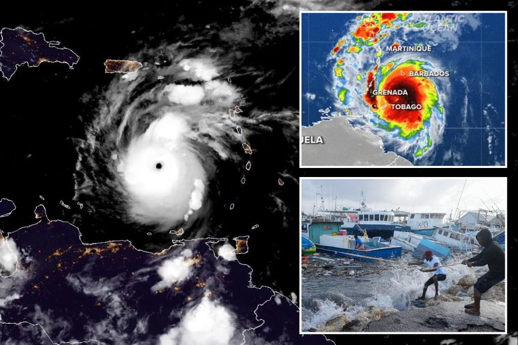
Just hours after Hurricane Beryl pummeled the Windward Islands with devastating winds and a powerful storm surge as major Category 4 storm, Beryl strengthened even further, reaching Category 5 strength on Monday evening and shattering the record for the earliest Category 5 hurricane observed in the Atlantic basin.
The National Hurricane Center said Beryl has peak wind speeds of 160 mph as of their 11 p.m. ET Monday update, now classifying the storm on the highest rung of the Saffir-Simpson hurricane scale, and beating Hurricane Emily’s climb to Category 5 status on July 16, 2005.
This all comes after the hurricane made landfall on Carriacou Island earlier on Monday.
Trees were toppled, power was knocked out and life-threatening storm surge sent water rushing inland across the southern Windward Islands after extremely dangerous Hurricane Beryl made landfall as a high-end Category 4 storm.
The storm produced catastrophic winds, which battered the region as terrified residents hunkered down in their homes and shelters, waiting for the storm’s fury to pass.
Hurricane Beryl was a Category 3 hurricane earlier on Monday morning, and with each update from the National Hurricane Center (NHC), the monster storm’s wind speed kept increasing, its pressure kept dropping, and it eventually reached a high-end Category 4 hurricane with winds of 150 mph before making landfall in Carriacou Island, Grenada.
Then came a dire warning from the NHC that residents should remain indoors until the storm had passed.
“This is an extremely dangerous and life-threatening situation,” the NHC said.
“Residents should not leave their shelter and remain in place through the passage of these life-threatening conditions.”
The NHC said Hurricane Beryl produced a sustained wind speed of 92 mph at Grenada airport, as well as a devastating wind gust of 121 mph – as strong as a Category 3 hurricane on the Saffir-Simpson Hurricane Wind Scale.
St. Lucia also experienced potentially dangerous impacts from Hurricane Beryl. The NHC said the island reported a sustained wind speed of 52 mph and a wind gust of 63 mph.
Hurricane Beryl became the second named storm of the 2024 Atlantic hurricane season and made history while the storm rapidly intensified from a tropical depression to tropical storm and then a major hurricane (Category 3 or higher) in less than 48 hours.
For those who live in the region, the weekend was spent preparing for the storm’s onslaught by placing coverings on windows of homes, filling up gas tanks and picking up last-minute supplies after it became clear that Hurricane Beryl would continue to strengthen as it approached island nations like Barbados and St. Lucia, where Hurricane Warnings remain in place.
The office of St. Lucia Prime Minister Philip J. Pierre said all residents should remain indoors until the all clear is given after a nationwide shutdown was implemented ahead of Hurricane Beryl.
Hospitals and wellness centers on the island activated emergency plans, shelters were opened for residents, and police and fire departments were on high alert and ready to respond to emergencies should any arise during the hurricane.
The prime minister’s office also said utility crews would be out across the island in full force once Hurricane Beryl left the region.
Residents of Barbados prepared for the impact of Hurricane Beryl since the end of last week.
Barbados Prime Minister Mia Amor Mottley took to social media on Friday and then again on Sunday to urge her constituents to take the necessary actions to protect themselves from the storm.
While Hurricane Beryl’s worst wasn’t expected to hit the island, it could still have a devastating impact.
“We still need to be extremely vigilant,” Mottley said Sunday night. “You can tell that there’s bad weather in the atmosphere.”
The Barbados Light and Power Company said it did not plan to shut down electricity ahead of the storm, but emergency procedures were in place.
“Our protection systems are designed to automatically trip any circuits impacted by the hurricane,” the company said.
“Additionally, our teams will be in control centers throughout the night, monitoring systems.”
The island has also opened dozens of shelters for residents if needed, and Mottley asked residents to stock up on food and water.
While power wasn’t expected to be shut down ahead of Hurricane Beryl, the island shut down the water system in preparation for the storm.
The Barbados Water Authority said the shutdown of the water system was precautionary to protect the critical infrastructure.
Schools have also been closed across Barbados, and Grantly Adams International Airport closed at 7 p.m. Sunday.
The facility will remain closed until further notice.
Where is Hurricane Beryl?
As of the latest advisory from the National Hurricane Center (NHC), Hurricane Beryl was about 510 miles from the Dominican Republic.
Hurricane Beryl has intensified again with maximum sustained winds of 160 mph and a minimum central pressure of 938 millibars, making it a Category 5 on the Saffir-Simpson Hurricane Wind Scale.
Hurricane-force winds (74-plus mph) extend outward up to 40 miles from the center, and tropical-storm-force winds (39-plus mph) extend outward up to 125 miles.
The NHC said that a weather station at Hewanorra International Airport in St. Lucia reported sustained winds of 47 mph and a gust of 64 mph.
There have also been multiple reports of downed trees, flooded streets, power outages and storm surge flooding in the Grenadines, Grenada, Barbados and Tobago.
On Beryl’s forecast trajectory, the storm’s center is currently moving into the southwestern Caribbean Sea after crossing the southern Windward Islands and will continue on its west-northwest path over the next few days.
On that track, Hurricane Beryl is forecast to remain a powerful hurricane as it moves across the Caribbean Sea on Tuesday with hurricane conditions possible in Jamaica, where a Hurricane Warning is in effect.
The NHC said the Cayman Islands, Belize and the Yucatan Peninsula and the southwestern Gulf of Mexico should continue to watch Beryl’s progress closely.
