A forecast model shows the different paths Hurricane Beryl may take as it closes in on the southeastern Caribbean.
The Category 4, “extremely dangerous,” storm is expected to make landfall on Monday, after it strengthened through the weekend.
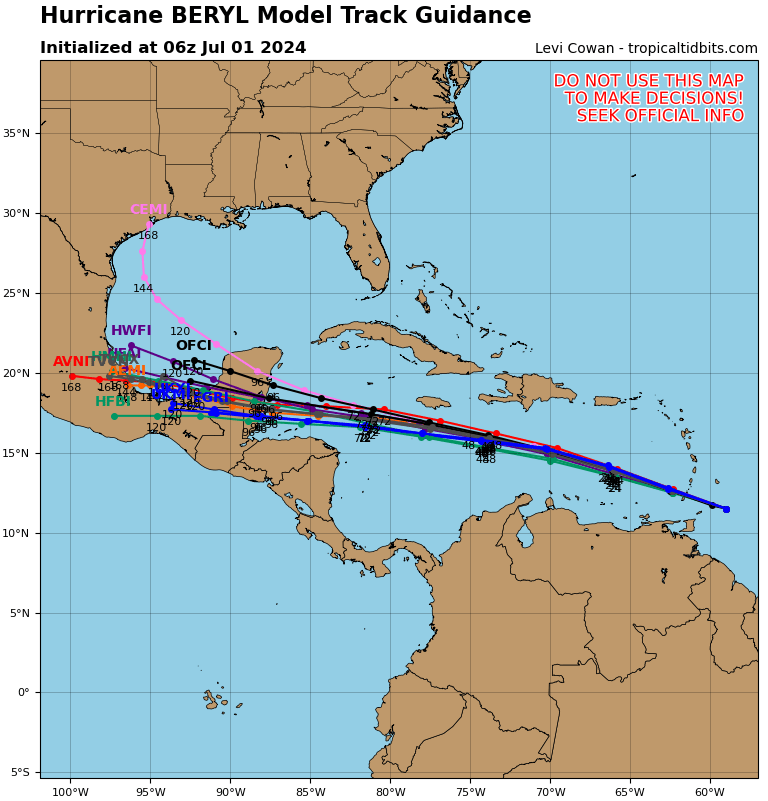
A so-called spaghetti model, made by hurricane-tracker Tropical Tidbits, shows several different possible routes. They include the most commonly forecast one, which predicts Beryl will move westward through the Caribbean, into Central America.
Other models, such as the Canadian Ensemble Mean Interpolated (CEMI) one, show Beryl turning southwest, possibly affecting the Yucatán Peninsula and the Gulf Coast of the U.S. The storm could also head more toward the southwest, hitting areas on the Central American coastline.

Tropical Tidbits
“Beryl is nearing the Windward Islands and expected to make landfall
within the next few hours,” the National Hurricane Center said in its most recent update.
Hurricane warnings are currently in place for Barbados, St. Vincent and the Grenadine Islands, Grenada and Tobago.
Some governments have changed their alerts to a tropical storm warning – in Martinique, Trinidad and St. Lucia.
Meanwhile, tropical storm watches cover the south coast of the Dominican Republic, from Punta Palenque westward to the border with Haiti, and the south coast of Haiti, from the border with the Dominican Republic to Anse d’Hainault.
The National Hurricane Center defines a hurricane warning as meaning that “hurricane conditions are expected somewhere within the warning area.”
“The preparations to protect life and property should be rushed to completion,” it adds.
A tropical storm warning means “tropical storm conditions are expected somewhere within the warning area within 36 hours” and a watch indicates “tropical storm conditions are possible within the watch area, generally within 48 hours.”
Other areas that could be affected by Beryl, according to the Central Pacific Hurricane Center, include the Lesser Antilles, Hispaniola, Jamaica, the Cayman Islands and the rest of the northwestern Caribbean.
In the National Hurricane Center’s previous update at 8 a.m. AST, it said Beryl was around 70 miles east of Grenada and about 90 miles southeast of St Vincent.
Maximum sustained winds were measured at 165 mph, with forecasters calling them possibly “life-threatening.”
The Center said: “Hurricane conditions are expected in the hurricane warning area beginning early this morning. Potentially catastrophic wind damage is expected where the core of Beryl moves through portions of the Windward Islands, with the highest risk of the core in St. Vincent and the Grenadines, and Grenada.
“Wind speeds atop and on the windward sides of hills and mountains are often up to 30 percent stronger than the near-surface winds indicated in this advisory, and in some elevated locations could be even greater.”
Uncommon Knowledge
Newsweek is committed to challenging conventional wisdom and finding connections in the search for common ground.
Newsweek is committed to challenging conventional wisdom and finding connections in the search for common ground.